Mile 2,508.1 to Mile 2,526.27

Mile 2,508.1 to Mile 2,526.27

Sunday, August 9, 2015
Day 9: Mile 2,508.1 to Mile 2,526.27
Miles: 18.26
Total Miles: 2,526.27
Miles to Go: 132.64

This was, without a doubt, the most challenging day I had ever had on a trail.

Our Krav alarm went off at the same time as usual only today it sang a different tune.

“Who’s ready to get killed by elevation today?!” Krav yelled giddily from his tent.

Purple laughed. I smiled and sighed. We were in for an ass-kicking, and we knew it.

According to our Halfmile App, 5,929 feet of elevation gain and 7,697 feet of elevation loss stood between us and our intended campsite eighteen miles up the trail.

We couldn’t hike fewer miles because between mile eleven and mile eighteen was nothing but steep switchbacks that marched down to the Milk River and right back up the far mountain. I knew we were going to be wasted by the time the day was done, but there wasn’t a lot we could do about but get up and start putting one foot in front of another.

We would have a few miles of nearly flat trail before, as Krav liked to call it, “we would get killed by elevation.” Setting aside my worry of how scary the steep bits would be, I set to making breakfast.

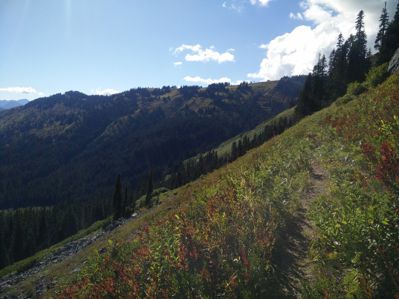
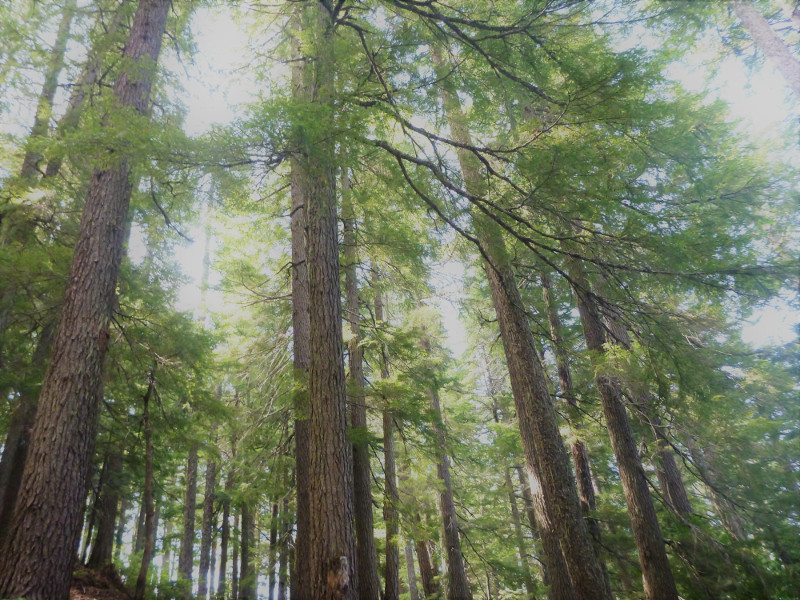
For the first few miles, the trail stuck to the Chuck River valley and was indeed pretty mellow as it worked its way through the forest. Near the trail junction to the Kennedy Hot Springs – which rumor had it had been destroyed in a landslide – the PCT turned and followed Kennedy Creek towards our first big climb up Kennedy Ridge.

The old log bridge at Kennedy Creek had snapped in half, and the center was sitting in the middle of the creek. Early in the day, the water was low enough that the center of the bridge was only mildly wet.

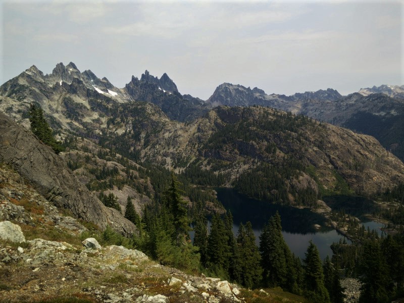
The climb up Kennedy Ridge was mostly forested, with the occasional dramatic view of Kennedy Peak and the Scimitar and Kennedy Glaciers, to break up the monotony of the trees.

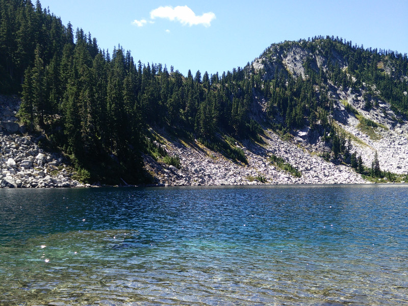
We stopped for water at the mossy Pumice Creek, reveling in the fact that the first climb was nearly over and that it that it really hadn’t been that bad at all. Only two hundred feet of elevation gain separated us from Spitfire Creek Pass!

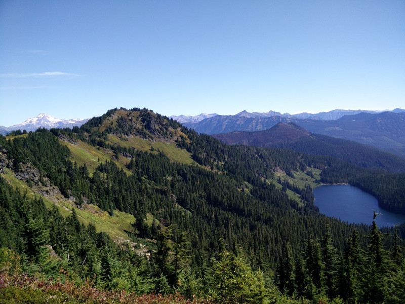
You know that feeling when you feel like you are on top of the world? That was how we felt when we got to the top of the pass and dropped our packs. Peaks rose up like waves around us; range, after range, after whitecapped range.

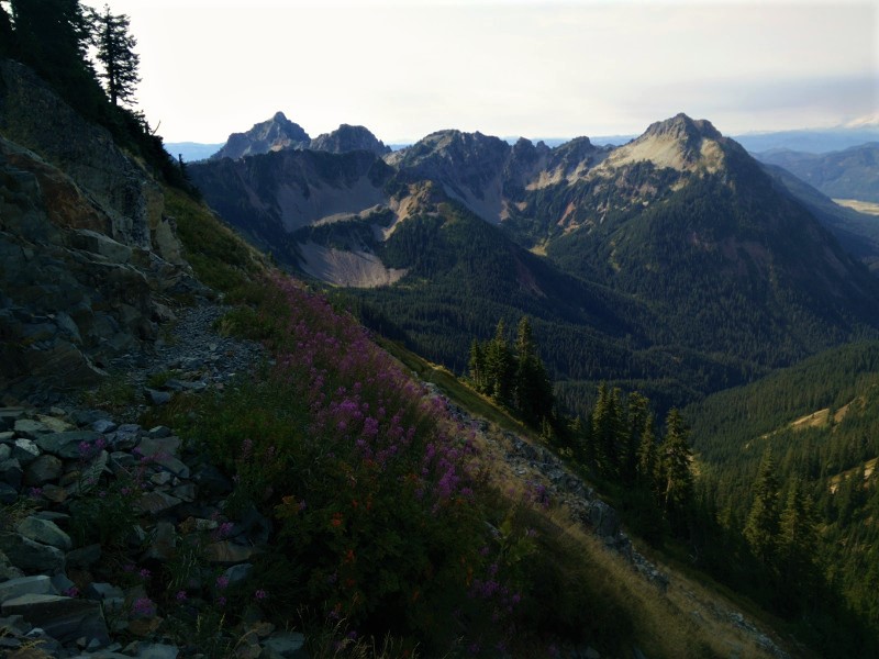
Far off, we could see a plume of smoke rising from the North Cascade National Park fire. It looked serious. This would be the reason for tomorrows detour.

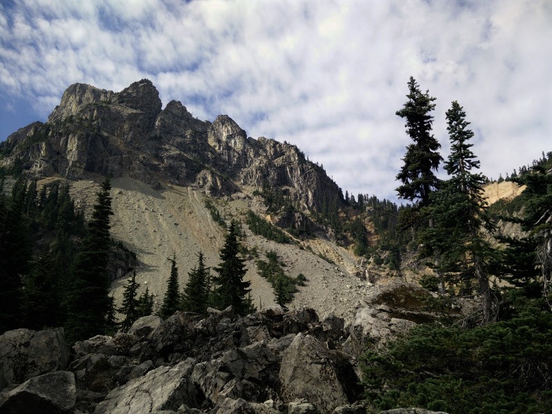
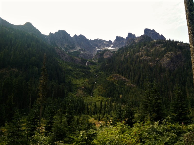
Not so far off, we could see the familiar pattern of tight switchbacks crisscrossing an overgrown avalanche shoot. Ugh, this would be our last big climb.

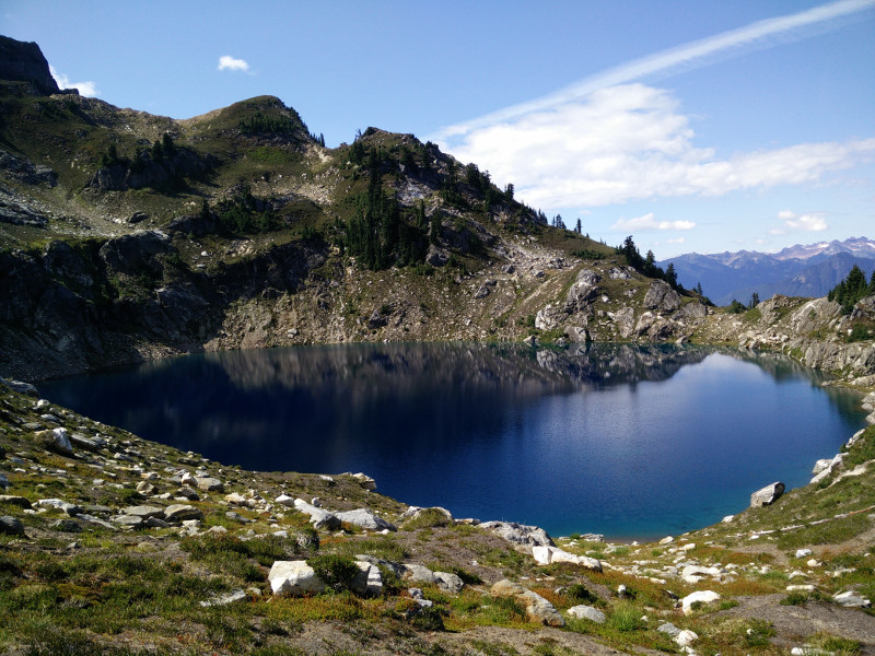
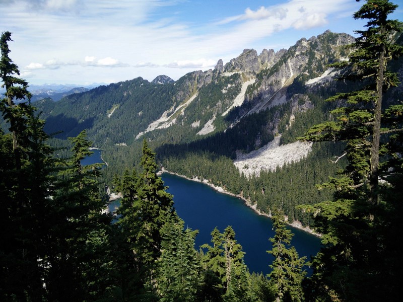
Just before we dropped down off of the pass, we stumbled across Mica Lake. Too perfect to just pass on by, we sat down in the shade of a huge boulder and had a late lunch. Supposedly, there was a campsite somewhere nearby; the views were so mind-blowing we were tempted to find it, make camp and stay until the snow began to fall. This was the only campsite between us, and the far side of the switchbacks that taunted us from the other side of the valley.

No, we were on a mission, we were finally going to get to Canada, and we weren’t about to get distracted, or let anything stop us.

For five miles we switchbacked down the mountain, through enormous old trees. At times, the trail was washed out, and we would be forced to detour around it. At times, we would find an old-growth tree blocking our path. Finding a way over them, was a task in itself. Besides these random obstacles, the trail was wide and smooth, and for that I was grateful.

We sat down in the middle of the Milk Creek Bridge and filtered water. It was late afternoon, and none of us wanted to climb back out of the valley. We considered making camp on the bridge, but it was early, and undoubtedly hikers would still be coming by for hours yet. Besides, the water was glacier fresh, and we knew camping on the bridge would make for a cold, damp night.

Knowing we would be destroyed after another 3,000-foot climb, and unsure if we would make it to a camp with water before dark, we decided to eat dinner on the bridge. If I’m being honest, it was just another excuse to procrastinate.

With dinner eaten and no other excuses we could think of, we heaved our packs onto our backs, crossed the bridge and disappeared into the forest on the far side.

The climb was not as brutal as we had imagined. Just long, so long. Switch. Switch. Switch. Are we there yet? Switch. Switch. Oh, a raspberry! Are we there yet? For hours we worked our way up the mountain. What the Milk Creek Valley portion of the PCT needed, was a zip line.

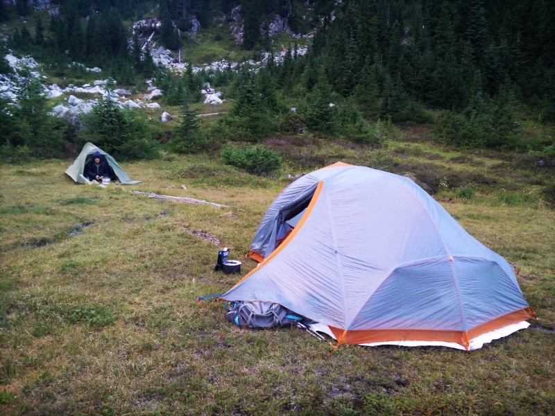
Krav, as always, was somewhere far ahead of us. From the top of the last set of switchbacks, we were still nearly three miles from our intended camp. Secretly, I wished we would find Krav waiting for us on the side of the trail so we could find a spot sooner, but we had agreed on getting to the campsite at mile 2,526.27, and I knew that was where we would find him.

Sure enough, Krav was in camp, just setting up his tent when we arrived. He looked as exhausted as we felt. With dinner already eaten, we crawled into bed, popped a handful of Vitamin I, and fell asleep to the shrill call of pika’s warning each other of our presence.

Janus Lake to Mile 2,498.4

Janus Lake to Mile 2,498.4

Friday, August 7, 2015
Day 7: Janus Lake to Mile 2,498.4
Miles: 18
Total Miles: 2,498.4
Miles to Go: 168.81

Up early, I sat on the edge of a log and watched the mist roll off Janus Lake, as breakfast cooked. The fog slowly lifted to reveal a perfectly mirrored image of the surrounding hills.

A friendly Clark’s Nutcracker flitted around my head, landing on nearby branches and rocks, hoping whatever I was making would be shared. Blindy, the one-eyed squirrel, ran in little circles near my feet, close enough for handouts, but far enough away to feel safe.

I wondered at this little squirrel; how he had lost his eye, and how much more difficult his survival would be with this disadvantage. Even though I knew I shouldn’t, I tossed them both a few scraps of oatmeal. Something about sitting there, in the quiet morning, surrounded by forest animals, made me feel a little bit like Snow White, only less clean and dainty.

Reluctantly saying goodbye to my tiny one-eyed friend, we left Lake Janus and began to climb towards Grizzly Peak. The higher we climbed, the more the views opened up, and soon white-capped peaks were poking up behind the jagged green hills in nearly every direction! Everywhere we looked was postcard perfect – rolling green meadow, met steeply forested hills, that ended in distant white peaks jutting into a cloudless, bluebird sky. Suddenly, a small part of me was happy we had not made it to the end of the trail in 2013 because we would have missed all this beauty in our race against the looming grey of fall in Washington and the impending winter; what a shame that would have been.

Rounding a corner, Glasses Lake sparkled cobalt blue in a forested bowl far below the trail; ahead, Glacier Peak loomed in the distance, it’s glaciers reflecting the brilliant mid-morning sun. My heart sang a song that it had not sung for far too long.

Past Glasses Lake, we entered a long meadow, chock full of ripe huckleberries. Bearclaw and I meandered through, picking fistfuls of berries as we went. Halfway up the meadow, we found Krav, pack off, sitting in the middle of a giant huckleberry patch just off the trail. When he saw us, he turned and smiled; his smile so blue it rivaled the August sky.

We rounded Grizzly Peak, and the views just kept on coming. We stopped briefly for water near the Top Lake Trail Junction and debated having lunch. The junction itself was nothing special, and there was a large lake a half a mile or so up the trail, and so we decided to continue. It was the right choice!

Deep, crystal clear and frigidly cold, Pear Lake was tucked into a talus and pine tree lined bowl just off the trail. We worked our way down to the shoreline and found some large boulders to lunch on. There we met thru-hikers Crow and Lady Bug. Crow and Lady Bug told us all about the Goldymire Hot Springs they had once caretaken.

It sounded pretty sweet and almost made us wish we had taken the Goldymire Alternate out of Snoqualmie… But then we wouldn’t have been on the PCT, and that is what our hearts had truly wanted.

During lunch, we decided to make Lake Sally Ann, nearly nine miles further up the trail, our goal for the evening.

In crazy thru-hiker shape, Crow and Lady Bug vanished within minutes; they were the only people we encountered, and besides a crazed deer we met at Saddle Gap, we had the trail completely to ourselves.

We dropped down to Pass Creek late in the afternoon and stared up at the 1,200-foot climb on the other side. We were tired, and not at all motivated. On the other hand, the thought of starting a new day with a 1,200-foot climb seemed somehow worse. Deciding to go for it, we ate dinner at the creek in preparation for a late night.

The sun had sunk behind the distant mountains, and the last of the light was fading when we decided to call it a day. We were still a mile from Sally Anne, but we were exhausted, and no one relished the idea of stumbling into camp well after dark.

A five-minute search revealed that the only semi-flat, non-rocky piece of ground in the area was a craptastic space in a dense thicket of gnarled trees. It was barely big enough for one tent, but we were wasted, and so we guessed it would do. Pitching our tent, the three of us crammed in and instantly feel fast asleep.

Deep Lake to Mile 2,451.48

Deep Lake to Mile 2,451.48

Tuesday, August 4, 2015
Day 4: Deep Lake to Mile 2,451.48
Miles: 19.01
Total Miles: 2,451.48
Miles to Go: 207.43

Having gone to bed long before sunset, we were up at the ass-crack of dawn, ready to hike. Even with a leisurely morning breakfast, we were still the first group to leave the lake. Hopping over the stones that crossed the outlet, we made our way up the series of switchbacks that lead away from the lake towards the top of Cathedral Pass. Still shaded from the morning sun, we hiked fast just to stay warm, watching the alpenglow that bathed the spire of Cathedral Peak slowly work its way further down the hillside. By the time we reached the top of the pass, even the deepest parts of the valley were bathed in the glorious warm morning sun. As we sat down to strip off unwanted layers, Tin Man and Crawfish cruised up behind us.

Tin Man and Crawfish never said much, and when they did, we got the distinct impression they felt as if we’d entered into an unspoken competition with them. A competition they were more than confident they would win. Krav, Bearclaw and I weren’t at all competitive, so it just made our run-ins with them awkward. Eager to beat us to where ever they thought we were going, they barely stopped at the top of the pass long enough to take in the view before they were gone again. The few conversations we’d had with them had been so uncomfortable I secretly hoped they’d stay ahead of us for the rest of the trail.

From Cathedral Pass, we had two options: staying on the Official PCT or take the alternate around Hyas Lake on the Robin Creek Trail.

Our HalfMile Maps had the following warning, “The potentially difficult ford at WA2439 may not be passable early in the hiking season after a high snow year.”

The alternate appeared to add a lot of extra miles, and it was late in a hot, dry year, so we stuck with the official trail, which worked its way high above Hyas Lake—a long navy gem at the bottom of the broad forested valley.

I’ve only been intimidated by high creek crossings once or twice in my life, mostly because I’m rarely out in the mountains in adverse weather. Call me a “fair weather” hiker if you will, but marching through early spring snowpack isn’t my thing. My last high-creek crossing had been recent enough that it played in an unstoppable loop in the back of my mind as we hiked up the trail towards the “potentially difficult ford.”

Earlier in the year, BunnySlayer, Bearclaw and I had gone on an overnight backpack into the Deschutes River Canyon. Just before camp, we’d crossed the thigh-deep, swiftly flowing waters of Whychus Creek a few hundred feet upstream from its confluence with the Deschutes River. It hadn’t been a simple hop-skip-and-a-jump, but it also hadn’t been anything we couldn’t manage. That night, however, it rained high up in the mountains, and when we awoke the next morning, the Deschutes was noticeably higher. This did not bode well for the water levels in the creek, we thought. Sure enough, the tender, early spring shoots of grass that lined the creek banks were now submerged under a good half a foot of water.

Experienced at hazardous water crossings, BunnySlayer had valiantly offered to cross first. We watched as he forced his way across the creek one deliberate step at a time.

“You’re going to want to make sure and be downstream of her when you guys cross,” BunnySlayer warned Bearclaw after he’d safely reached the far side.

Two steps in and the icy cold water was already lapping at my unbuckled hip-belt. My legs stung, my poles vibrated with such force that I could barely keep them in my hands. Two more steps and I couldn’t even force my poles to meet the creek bed. Halfway across the creek, the current was so intense it pushed my feet along the pebbly creek bed. I was being pushed downstream, and there wasn’t a damn thing I could do about it.

“Um, my feet are moving on their own you guys.” I was upright, but I knew if I slid into a big rock I wouldn’t be for long. From the bank, BunnySlayer could see the fear in my eyes.

“You’re going to need to grab her.” He told Bearclaw, who was one step ahead of me, fighting the current himself. Bearclaw turned around and grabbed my arm. Together, he and BunnySlayer pulled me onto dry land.

As we made our way towards this “potentially hazardous ford” I could still feel the unease of having no control over my own feet, and I wasn’t a fan. Theoretically, I know the basics of what you’re supposed to do if you’re swept downstream, but I’d rather not have to test this knowledge. Preferably, ever. “Remove backpack and swim to shore,” sounded simple on land, but I have a feeling the level of difficulty grows exponentially when you can’t see and are trying desperately not to drown.

The closer we got to this unnamed creek, the more overgrown the trail became. “What if no one comes this way because of how scary this crossing is?” I thought. It was late in an extremely dry season, how bad could it be? Hell, practically the whole State of Washington was on fire from what we’d heard. But what if this creek was fed by glacial melt and August when it was at its highest?

By the time we got to the creek, I’d worked myself into a complete state of anxiety. It didn’t help that we could hear the water long before we could see it. With each step leading up to the crossing, I became more and more convinced I was probably going to be swept downstream and into Hyas Lake far below.

Popping out of the brush, I could’ve burst out laughing. My big scary crossing was through an eight foot wide, calf-deep stream that worked its way through a tangle of boulders in a narrow avalanche chute. Where the trail crossed, someone had placed a mess of small logs and rocks. I’m sure during spring runoff the water roared down the chute with the ferocity of a lion, but in August it was as tame as a kitten. Three steps and I was on the far bank.

The good thing about mentally working yourself into a heightened state of anxiety over an imaginary situation is the feeling of euphoria you get when it doesn’t happen. On the far side of that little stream, I felt more alive than I had in days, maybe even weeks. Thank you adrenaline!

Funny how it isn’t the stuff you worry about that ends up getting you in the end. Instead, it’s the unpredictable stuff you could never possibly imagine that nearly kills you. Like for instance when the Air Force nearly caused me to have a heart attack and drop dead three miles further up the trail.

We’d just stopped for lunch, and I was admiring a massive conk fungus growing on the side of an old growth tree when suddenly the ground began to shake, and a sound like a freight-train reverberated off the mountains around us. I’d been so lost in thought, and the sound was so out of place, I was sure the world was coming to an end.

“What the hell is happening?” I yelled, instinctively ducking for cover behind Bearclaw.

Bearclaw and Krav watched silently as two fighter jets roared overhead, then turned to look at me as if I’d lost my damned mind. Embarrassed, I cussed out the Air Force for sneaking up on me unprovoked, then sat down to lunch.

Imaginary drowning and being attacked by the Air Force in one morning was too much for me. Out of energy, the afternoon dragged on as we walked through the woods on our way up to the tranquil shores of Deception Lake. Deception Lake was heaven on earth. Deep, green and completely enveloped in a serene pine forest. While Krav opted to use the energy he had to power to the top of Piper Pass, Bearclaw and I lounged in the shade of the trees closest to the shoreline for as long as we could. Bearclaw tried to convince me to go for a swim, but I didn’t have enough energy left to worry about lake monsters.

We stopped again at the top of the pass to admire the view of Glacier Lake far below. Noticeably lacking glaciers, or views of glaciers, or hard packed snow of any kind, Glacier Lake was not at all what I had expected. On the far side of the lake, I could see the remnants of the old Cascade Crest Trail hugging the talus slopes. I wished we were staying high, instead of dropping down to the lake and then having to climb up the switchbacks on the far side. I was too tired for switchbacks.

Getting late in the day, we stopped near a spring at the bottom of our last climb and ate an early dinner in the middle of the trail. While we were eating, two groups of hikers passed by. The first was a group of five weekend warriors. They looked annoyed and exhausted as we tucked our legs in to let them pass. The second group was two through-hikers, FluffyStar and Monk. They were quite taken by our choice of dinner locations. After all, we had clean water that didn’t need to be filtered and a flat place to set our stoves.

Concerned we were all headed for the same campsite; we asked what their destination was for the evening. FluffyStar could not contain her excitement as she told us they were going to push on for eight more miles because she had read on her map that Mig Lake had an outhouse.

Eight miles, for an outhouse? I wouldn’t have walked eight miles for a hamburger. In fact, I doubted I had the three more we needed to get to camp. How could I possibly be this exhausted after only four days?

I slowly crawled up the switchbacks on the far side of Glacier Lake, lagging further and further behind the boys. Two miles from camp, we circled a magnificent lake nestled into the bottom of an alpine bowl. Oh, how I wanted to stop and camp at that little lake. But alas, it was a good two-hundred and fifty feet below the trail, and I was too tired to veer that far off course. Besides, I could see two tents near the outlet, and if I climbed all the way down there only to discover there were no more campsites, I’d have to climb all the way back up.

A mile and a half later, we stumbled into a small meadow with a babbling brook. Grateful we’d already eaten dinner, I fell asleep to the shrill “peeps” of our pica neighbors, happy to have survived another day on the trail.

Ridge Lake to Small Tarn Mile 2,417.56

Ridge Lake to Small Tarn Mile 2,417.56

Sunday, August 2, 2015
Day 2: Ridge Lake to Small Tarn Mile 2,417.56
Miles: 19.58
Total Mile: 2417.56
Miles to Go: 248.67

“TIME TO GET UP!” Krav yelled from his tent. It was 6:00 a.m.

I’d totally forgotten about the Krav alarm! I rolled over and popped out of the tent, pleasantly surprised my feet, calves, and hips had made a more-or-less full recovery.

I sat down cross-legged on a bare piece of ground and started to make breakfast. To my right, the mountains the trail would be contouring around were awash in the soft peach glow of the early morning sun. To my left, in typical hikertrash style, Krav was making himself breakfast from bed. Behind him, a pika scampered up a large half-moon shaped boulder in the talus field and greeted the new day with a piercing “PEEP!”

Oh, my God, a pika! I’m of the opinion there is no cuter animal in the forests of the Northwest. Hell, even marmots are homely in comparison! (Sorry, marmots, I still love you, but we both know it’s true.)

Although the American Pika was denied federal endangered species status in 2010, their populations are dwindling. Because pikas’ habitat is limited exclusively to rocky talus fields in high mountain ecosystems, they’ve adapted to a very specific set of living conditions. The excessive heat and mild winters brought on by global warming have been lethal to pika populations across the Northwest. I felt lucky just to be seeing this little guy.

“There’s a pika!” I whispered to Bearclaw and Krav.

“Ha! It looks like a furry burrito with legs.” Krav laughed when he finally spotted it.

Abandoning breakfast, I grabbed my camera and every so slowly tiptoed towards the rock pile. I made it three steps before the pika let out one loud warning “peep” to all his little pika friends and disappeared beneath a rock. Even though I’ve gone from trying to pet every animal I see, to simply trying to sneak up and photograph them, my ongoing attempt to integrate myself into the wildlife population has thus far been a monumental failure. Wildlife: 10,482 Hummingbird: 0.

Passed Ridge Lake, the trail clung precariously to the steep wildflower filled mountainsides of the Chikamin Range. With every turn, new views of pristine alpine lakes nestled in dark green forests, and valleys that seemed to go on forever, spread out before us. Joe Lake especially caught my eye. If I’d have known yesterday how spectacular it was, I would’ve hiked the extra two miles past Ridge Lake and camped there instead! Within the first three miles of trail, Bearclaw and I had stopped to take so many pictures that Krav was nowhere in sight.

I’ve always found it interesting how all-encompassing the phrase, “Hike Your Own Hike” really is— from gear and clothing preferences, to how you interpret and choose to apply LNT principles, to the simple act of how you walk a trail. Hiking is one of those things that there is no “one way” to do. You can ask a thousand people how they hike, and you will get a thousand answers. Take for instant Krav, Krav knows he is at his best when it’s cool. In the morning, he gets on the trail, and he is gone within minutes. You can’t catch him, very few people could. The hotter it gets, the slower he becomes. His solution is to “kill” as many miles as he can, as quickly as he can. On the other hand, Bearclaw and I are slow and steady all day long. At some point around noon, we catch up to Krav for lunch, and for hours after that, we will be ahead of him. As soon as it cools off in the evening, he’ll blow by us again, and we won’t see him until camp. Besides the fact that we beat him to camp, today was no different.

When Bearclaw and I stopped for a morning break on a low saddle above the Park Lakes, we asked a German hiker heading in the opposite direction if he’d seen Krav.

“Yes, I saw a man that fits that description about twenty minutes ago. He was going quite fast.” Yup that would be Krav!

Even though Bearclaw and I picked up speed as we headed down the tight switchbacks leading around the edge of the stunning Spectacle Lake, it was nearly one o’clock when we finally caught up to Krav, cooling off in a pool halfway up Delate Creek Falls.

“It’s warm!” He assured us, as we crossed the footbridge below the falls.

I had my doubts, but it was hot enough that dropping my pack and splashing around in the shallow pools of a picture perfect waterfall sounded incredibly inviting. Hours passed before we reluctantly pulled ourselves away from the creek and continued up the trail. No one was looking forward to the 2,200-foot climb that would end our day. The trouble was this: we either had a fourteen-mile day with no climb at the end, or we hiked a twenty-mile day to the next available campsite at the top of the climb. There was nothing in between. At breakfast, we’d decided to go big.

At mile 13.9, the campsite at mile fourteen was starting to sound mighty tempting. However, when we arrived, the decision was made for us— a father/ son section hiker duo, Tin Man and Crawfish, had already set up camp there. Twenty miles it was.

Knowing we’d be so exhausted by the time we made camp that the simple task of setting up the tent would feel as complicated as disarming a ticking time bomb, we stopped at the last water source near the base of the climb for dinner.

“Are you ready for this?” Bearclaw asked as we packed up to leave.

I did a quick inventory. My ankles, feet, and hips were killing me, but that meant they still had feeling, which meant I was still alive, so that was a good start. I was exhausted. How we consistently did twenty-five mile days on the trail was a mystery.

“Nope, but let’s do this,” I replied.

“All you have to do is keep putting one foot in front of the other,” I told myself as we headed up the trail. I used the waterfall thundering off the glaciers of Lemah Peak on the far side of the valley as a measuring stick.

Every few switchbacks, I would come to grinding halt to see how much progress we’d made. Ever so slowly, “We’re almost halfway up the falls,” turned into, “We’re at the top of the falls,” turned into, “Yay, now we’re in line with the lower glacier.” Things were going fine until, half a mile from camp, I was reunited with my nemesis the fallen log. This particular log was one of those logs that was impossible to go around, impossible to climb under, and just the wrong height for easily going over.

“Oh hello, exhausted little Hummingbird….Did you miss me? Muhahahaha!”

Stupid, log.

Painstakingly lifting one leg over, I lay there like a cheetah hanging out on a tree limb, both legs and arms dangling over the sides, a good six inches off the ground.

“I’m stuck,” I mumbled to Bearclaw, my face smashed up against the bark, “Can you push me?”

He reached out and gingerly gave me nudge until I slid like Jell-O off the far side.

“Great, now how am I going to get over?” He looked as exhausted as I felt.

“Just swing your leg over, and I’ll pull you.” I offered pathetically.

Accepting this as a viable solution, he swung his leg over the log. I tugged on his backpack until he too slid over, and we both found ourselves on the winning side.

The log defeated; we stumbled into a sandy campsite tucked alongside a shallow tarn just in time to watch the sun set behind Lemah Peak. The last of the light hadn’t even faded from the horizon before we were fast asleep.

Mirror Lake to Snoqualmie Pass

Mirror Lake to Snoqualmie Pass

Saturday, August 23, 2014
Day 9: Mirror Lake to Snoqualmie Pass
Miles: 9.1
Miles to Go: 0

It was hard to be motivated to get out of bed knowing we were only nine miles from the end of the trail. I wanted to return to reality now, about as little as I had when we’d left Packwood after the storm. I had no desire to return to real life because somehow, it never seemed real. It always felt like something was missing. Hiking felt real, traveling felt real, adventuring felt real, living life to its absolute fullest felt real.

Work was really just something I did so I could afford the real moments. It seemed wrong to me that we had to buy our own free time.

At least since we’d gotten off the trail, I’d found a job I enjoyed doing and was working on a side project I absolutely loved. For that I was grateful. Most people I knew would say they tolerated what they did for work at best. I found that sad. If we’re lucky, we get ninety years on this marvelous planet and a third of that time is spent sleeping. It seemed like such a waste to spend two-thirds of the time one was awake miserable. Society felt like giant mouse-trap: you need a car to get to work so you can make money to pay for the car that got you there and the house you never spend time in because you’re too busy making money to pay for it. Sometimes I wonder if we just do things because that’s the way things have always been done and the system wouldn’t work if we collectively believed they could be done any differently.

What would happen if everyone suddenly realized they could be happy with just what was in the backpacks on their back? Maybe I needed to start a hikertrash revolution.

Meh. That was enough of that. I was giving myself a headache. I shook my head. I couldn’t dwell on these things. They made me crazy, and quite frankly, crazier was the last thing I needed to be. Sighing, I crawled out of my sleeping bag and prepared for the inevitable.

Besides, we needed to be off the mountain before the ultra-runners came through. The runner we’d met on break yesterday had said Mirror Lake was a popular destination for well-wishers to come watch the runners go by and by midafternoon it would likely be packed.

The trail was still damp from last night’s rain as we made our way over the small hill behind the lake. From that point on, we knew it would be downhill all the way into town. With gravity pushing us along, we hiked fast. There was really no reason to prolong the inevitable; it’s always less painful to rip a Band-Aid off quickly, right?

The trail hugged the side of a steep forested hill for a good many miles as it worked its way down into Olallie Meadow. Passed Olallie Meadow, we crossed one forest service road and then another, before dipping under a power line. Ugh, power lines, gross. I was fully aware that I was a hypocrite for that because, the first chance I got, I had every intention of showering with water heated by the very power surging through those lines.

“Do you hear that?” Bearclaw asked, “It sounds like cars on a highway.”

“That’s because the I-90 is less than a quarter mile east.” I sighed.

Civilization was nigh. I had to fight the urge to wrap my arms around the base of a tree and scream, “No! No! You can’t make me! Save me tree!!” And yet, my feet kept moving me ever forward.

By the time we reached Lodge Lake, the trail was a highway in its own right, as weekend warriors and day hikers made their own escape into the wilderness. It wasn’t long before we popped over a rise and ended up on a ski run.

We were halfway down the ski hill on our way into Snoqualmie when we met a couple headed up the road toward us.

“Are you thru hikers?” They asked. I smiled. Every single conversation we’d had over the last nine days had started with those same four magical words.

We gave them the low down, letting them know that unfortunately, we were hiking our last few hundred yards of trail. They had a cabin a million miles from civilization and had spent years guiding pack expeditions in the backcountry, they felt our pain at the impending return to civilization.

The man looked at us thoughtfully. “I have a poem I think you might enjoy. It’s called Lost. It was written by a man named David Wagoner and was based on an ancient Native American teaching.”

His gaze flew over Snoqualmie and deep into the steep mountains beyond as he recited this poem from memory,

“Stand still. The trees ahead and bushes beside you
Are not lost. Wherever you are is called Here,
And you must treat it as a powerful stranger,
Must ask permission to know it and be known.
The forest breathes. Listen. It answers,
I have made this place around you.
If you leave it, you may come back again, saying Here.
No two trees are the same to Raven.
No two branches are the same to Wren.
If what a tree or a bush does is lost on you,
You are surely lost. Stand still. The forest knows
Where you are. You must let it find you.”

I’ve said it a hundred times before, and I will say it a hundred times again: The trail has a funny way of being able to read you and knowing exactly what to do, or who to put in your path, to make everything all right.

It didn’t matter if I was standing in the middle of a towering forest of pines, at the top of a mountain pass, had my toes submerged in the sand and surf of a deserted beach, or was lying on the sun-baked earth of the desert staring at the sparkling night sky, I never felt lost in nature. In nature everything had its place, everything had its purpose, and if I let it, it simply invited me into its rhythm. I became a small part of the big picture. Civilization was out of sync with the rhythm of nature, I wasn’t part of something bigger, and I didn’t have my place. I was lost. Out here though, I always knew where I was. I was “here” and “here” was home. It didn’t matter how long I had to be away, it would always welcome me back.

We ordered lunch at the stand in front of the gas station and plopped down at a picnic table to wait for Trenchstar to arrive with our car. When our order was ready, the girl behind the counter looked at us and asked the age-old question, “Are you guys thru-hikers? If you are there’s a free can of beer with your name on it.”

“Yes, we are,” I responded without hesitation.

Not because I really wanted a frosty beer but because I’d had a trail epiphany. You don’t need to be thru-hiking to be a thru-hiker, just like you don’t need to be a hiker to be hikertrash. These things, and where you call home, are more a state of mind than anything.

Miles Left to Canada: 258 — Stay tuned for the end of the story Summer 2015!